Donde Basics
April 23, 2011

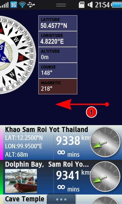
The first screen you see is the Direction screen. This is the main navigation hub for Donde.

Compass Direction Waypoints

  1. GPS Latitude and Longitude.
  2. The GPS Course. When you have a GPS position, the center of the dial will show a blue compass, which colour-matches the blue GPS location in (1). The Course is the direction you are moving. As the GPS location changes, the Course is calculated from the changing position.
  3. Magnetic compass direction (not DondeWQ). The phone contains a compass, and the red/black outer dial and red Magnetic (3)  show where the phone is currently pointing based on that compass.
  4. You waypoints, these are the places you want to visit. The series of targets to head towards. It’s a sliding list, slide it up for more waypoints.
  5. Notice the coloured bar down the left of the selected waypoint, and the same colour on the compass? To head to that waypoint follow the coloured bar, as you come close the bar becomes wider as the waypoint gets close.
  6. The three dots pull up the menu on Samsung Wave phones. Tap here to get the menu.
  7. (Not DondeWQ version). This speaker appears when you have a waypoint selected and a direction to head towards. It turns on Warbling Guidance.

Notice the coloured bar (5) matching the selected waypoints coloured bar, also marked with a (5). When you are far away this bar is narrow, and it widens the closer you get to the target. GPS is not perfect, it has a measurement error, the nearer you are the less the direction can be determined, and so the wider the coloured bar.

Near and Arrived state on the Compass

Nearly There, and Arrived States

Once your arrive at the GPS location, a pulsing circle shows you have arrived. GPS can’t get you any closer.

The same screen on DondeWQ looks like this:

If DondeWQ has a GPS signal but does not yet know the current course, then walking feet are shown, to prompt you to walk so it can calculate your course:

For DondeWQ, when you select a Waypoint, an arrow is shown, the arrowhead will grow larger the close you are to the target, with a pulsing circle when you arrive at your destination.
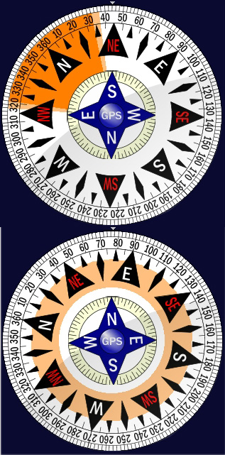
Arrow type in DondeWQ

Map Screen
April 21, 2011

The maps screen is an online feature of Donde. You’ll need an Internet connection to access it. To get to the map screen sweep the screen to the left.

Sweep the screen for the map

Sweep Screen for Map

  1. Sweep the compass to one side, and the maps will slide into view.
Map Screen Controls

Map Screen Controls

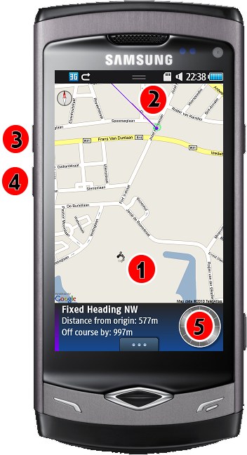
  1. Your current GPS location is shown in black with an extra dot to indicate direction.
  2. The green circle is the green waypoint. The purple line is the purple fixed heading from that waypoint.
  3. Zoom in using this button, it zooms into the selected waypoint & GPS location automatically.
  4. Zoom out.
  5. Your waypoints panel.

Add Item Screen
April 17, 2011

There’s more to the add item screen than simply adding locations by GPS coordinates or by searching the name.

Add Waypoint Screen

Add Waypoint Form

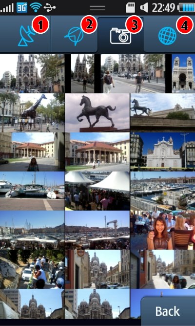
The tabs long the top offer several powerful ways to add waypoints.

  1. The GPS tab, adds locations based on their GPS coordinates.
  2. The course tab, lets you add fixed headings and do calculations, e.g. add a waypoint 1 km North West of a location.
  3. The tab shown above, is the photo tab. These are your photos in the Samsung phone, and it lets you search for photos you took earlier by their location. The photos in the example above are photos from Marseille sorted by nearness to that church you see in the first picture.
  4. The fourth tab is the web content tab. To use this you need an internet connection. It offers a wealth of internet data related to the GPS location.

The photo tab, shown above, lets you photograph key places as you walk, you can then navigate back to those places by searching the photos. To do this the GPS tagging feature needs to be enabled in your Samsung camera settings.

  • Click add on the main compass menu.
  • Your are taken to the GPS tab with your GPS location in it.
  • Tap the camera tab, the photos in the camera are searched for images near that location.
  • You can also enter different latitude longitude on the GPS tab and search for that.
  • For this example, I entered ‘Marseille’ in the name field, tapped search to obtain the location for Marseille, then tapped the camera icon to pull up my photos of Marseille.
Photo Zoom Up Marseille

Photo Zoomed Up

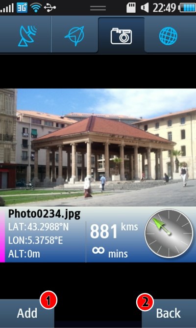
  • To add a photo as a waypoint, tap the small photo in the list.
  • The photo zooms up to fill the screen.
  • The GPS coordinates, distance from current location, direction and an estimate of how many minutes away it is, are shown.
  1. Tap Add to add it as a waypoint, the waypoint will be shown with a check on it in the list.
  2. Tap Back to return to the list.

Adding Geocache Locations
April 15, 2011

The forth tab on the Add form also lets you directly go to Geocaching.com. If you’re not familiar with Geocaching, it’s a game of hide and seek. Items are hidden at GPS location, and you find them, exploring new places along the way. Sometimes multi-caches are made, where a puzzle is solved along the way to find the next cache.

Geocaching

Adding Geocaching Locations

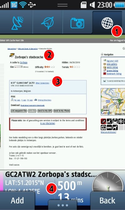
  1. Tap the globe to visit the web content (this part needs an internet connection, once you have the location to visit, you can navigate on compass and GPS alone without an internet connection).
  2. Tap Geocaching you will be taken to Geocaching.com website. You need to login or sign-up for an account to use this site. Geocaching will show a list of nearby caches, tap one you want to visit in the web page.
  3. Here you see the page has a geo-tag on it, showing the location of cache. Donde recognises the first of these on any page and offers it as a waypoint along the bottom of the page.
  4. Here the location of GC2ATW2, 500 metres south of my location is shown. I can tap Add to add this Geocache as a waypoint.

For multi-caches, add the later waypoints using the GPS tab as you solve each puzzle.

Wikipedia GPS Tagged Pages
April 12, 2011

Wikipedia tagged pages.

Wikipedia Waypoints

The web content tag also includes a Wikipedia search. You can search Wikipedia for pages related to the place you are at. Some of Wikipedia pages are tagged with a location.

  1. The GPS location of this article is shown here.
  2. Donde extracts this location and offers a waypoint along the bottom. That waypoint is 2.3 Kms SE from our location.